


One look at a map of Paris and it will be immediately clear why even the locals often need help navigating the tangled web of streets dating back two millennia. And so will you.
The Layout of Paris
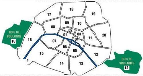
Paris is the capital of France and the center of the region known as Ile-de-France. It’s made up of 20 districts called arrondissements, starting at the center and spiraling clockwise like a snail. The Seine River runs through the city in a rainbow arc, dividing Paris into the Rive Droit (Right Bank) on the north and Rive Gauche (Left Bank) on the south. There are two islands at the center, Ile-de-la-Cité and the smaller Ile-St-Louis.
Useless Information: The “Left” and “Right” designation came about because people originally entered Paris by boat in medieval times, and since the Seine flows from east to west, the north side would be to the right and the south side to the left.
The city is surrounded by a ring road called the périphérique. Everything outside this ring road is outside of Paris city limits, including the airports, La Défense, and St-Denis (aka les banlieues, or suburbs).
Reading Addresses
The city’s 20 arrondissements are designated as 1st for 1st arrondissement, 13th for the 13th arrondissement, etc. In a mailing address, the full zip code incorporates the arrondissmentwith the department code for Paris: 75. So 75001 would be in the 1st and 75013 in the 13th. Métro stations are abbreviated as M° when part of an address, so the Métro Station St-Michel becomes M° St-Michel. Every once and awhile you may see a street number followed by bis , such as: 25bis Avenue des Champs-Elysées. It just means it’s next to #25, with a separate doorway.
Digital Maps
You’ll need a good map of Paris (even residents use maps to navigate the maze of Parisian streets). Smartphones have GPS and Google maps that will make your life a lot easier. My favorite map app is CityMapper, which offers every option (metro, bus, bike, walk, Uber, tram, RER) between destinations in Paris (and other major cities around the world). There are also many free offline maps you can download, like this one.
If you’re driving anywhere in France, Google maps and Waze are the best apps for the up-to-date closures and traffic jams due to construction works (Paris can be a nightmare in the summertime when most roadworks are done). Sytadin is the official Department of Transportation traffic information service for the Ile-de-France region, and is useful for realtime overview of closures, accidents, and construction in and around Paris.
Printed Maps
Even if you think you can use your smartphone, it’s still good to have a print map as well so you can draw on it, and have it handy when your battery dies or you have no reception (it happens!)
The Best Map of Paris, in my humble opinion, is the classic Paris par Arrondissement. For just under €10 at any Paris newsstand, you get a detailed map of each arrondissement with metro stations and major monuments and post offices designated, plus an index of street names, a metro and RER map, a bus map with the exact stops for each route, and even the suburbs. It’s what I — and most Parisians — use every day to get around. It has a non-tear vinyl cover and fits nicely in your purse or coat pocket. You’ll look like a local when you pull this out, not a tourist! Available at any newsstand in Paris or local book shop. Make sure it’s not older than 2007, since some streets and metro stops have been added.
The best fold-out map is the Paris Monumental. I was looking for a good one to use on tours so I could point out where we were in relation to the rest of the city and famous monuments. I found this one for €4.90 at the bookstore Gilbert Jeune (at Place St-Michel, the one on the corner closest to Notre-Dame). It’s a booklet with a directory of street names, and the map can be pulled out. One side of the map is 2-D and shows the entire city to the ring-road, with different colors for each arrondissement and every street clearly marked. On the other side is a cool 3-D map of the city’s monuments and major streets. I’m not sure what year it’s from, but the Bercy district is still full of wine warehouses, so it’s pre-1990, for sure. This map makes a good souvenir.
Most guidebooks come with a map, usually more than one: a general overview map, neighborhood maps, metro maps, monument maps… They can be helpful if they’re good (I like the ones in Fodor’s and Time Out; I hate the one my publisher created for my Adventure Guide), but there’s no way they can show every street. Paris is just too dense. There are guidebooks that focus on the maps, like the Moon Metro guides. Frommer’s has a decent tear-proof pull-out map, but only of the center of town, not the entire city.
Free maps at the hotel and tourism office are the big folding ones that end up ripping after two days, and they aren’t very good anyway (they don’t show all of the streets, and because they’re free they’re plastered with ads). I always think I’m going to go blind trying to read the street names, too. Still, they make great “throwaway” maps for marking up or highlighting where you need to go.
Maps in the Street
If you’re out and about without a map, there are a few good places to get your bearings. There are small publicity billboards on major streets, often with a map of the neighborhood and a red “vous êtes ici” dot showing where you are. There’s a map of the immediate area inside each bus shelter, and just inside every Métro station (you usually don’t need to go through the turnstile).


Add Comment